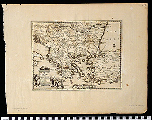
Map: Turquie en Europe
1992.08.0035
Detailed Images
Basic Information
| Artifact Identification | Map: Turquie en Europe (1992.08.0035) |
|---|---|
| Classification/ Nomenclature |
|
| Artist/Maker | van der Aa, Pieter. (1659-1733) Leiden. Galerie Agreable du Monde, 66 vols. |
| Geographic Location | |
| Period/Date | 1729 |
| Culture | French |
Physical Analysis
| Dimension 1 (Width) | 47.0 cm |
|---|---|
| Dimension 2 (Height) | 35.6 cm |
| Dimension 3 (Depth) | <0.1 cm |
| Weight | 16 g |
| Measuring Remarks | None |
| Materials | paper, pigment |
| Manufacturing Processes | Printed |
| Munsell Color Information | brown (5yr 2.5/1) -ns Dark Grayish Brown (7.5YR 2/2) -Shoreline. Dark Grayish Yellowish Brown (10YR 2/2) -Lettering. Yellowish Gray (10YR 8.5/2) -Background. |
Research Remarks
| Published Description | Map is entitled "TURQUIE EN EUROPE." There is a small illustration near the emblem showing a man from Europe and one from Turkey. Depicts Turkey, Europe, Greece. Map is surrounded by a measuring stick. |
|---|---|
| Description | N/A |
| Comparanda | N/A |
| Bibliography | N/A |
Artifact History
| Archaeological Data | N/A |
|---|---|
| Credit Line/Dedication | The Seymour and Muriel Yale Collection of Coins of the Ottoman Empire and Other Middle East States |
| Reproduction | No |
| Reproduction Information | N/A |