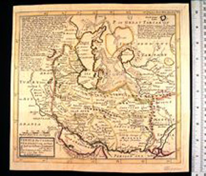
Map: Persia, the Caspian Sea, and Part of Independent Tartary
1988.07.0007
Basic Information
| Artifact Identification | Map: Persia, the Caspian Sea, and Part of Independent Tartary (1988.07.0007) |
|---|---|
| Classification/ Nomenclature |
|
| Artist/Maker | Moll, Herman: Cartographer (d. 1732) John Bowles & Son ( Thomas Bowles & John Bowles, Carington Bowles ): Publishers |
| Geographic Location | |
| Period | Georgian |
| Date | 1740 CE |
| Culture | British, English |
| Location | Not on Exhibit |
Physical Analysis
| Dimension 1 (Width) | 27.9 cm |
|---|---|
| Dimension 2 (Height) | 26.3 cm |
| Dimension 3 (Depth) | <0.1 cm |
| Weight | 9 g |
| Measuring Remarks | N/A |
| Materials | Paper, Pigment |
| Manufacturing Processes | Printed |
Research Remarks
| Description | N/A |
|---|---|
| Published Description | N/A |
| Bibliography | George, firm. The New World Book List. pg. 84. Bristol, England: William George's Sons, 1890. |
Artifact History
| Credit Line/Dedication | The Seymour and Muriel Yale Collection of Coins of the Ottoman Empire and Other Middle East States |
|---|---|
| Reproduction | no |
Contact
All information about our collection is constantly reviewed and updated. Please contact Dery Martínez-Bonilla, Registrar, if there is any information you are looking for that isn't currently online.