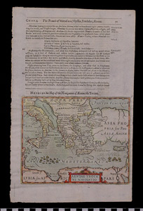
Map: Navigation of Aeneas the Trojan
1988.07.0015
Detailed Images
Basic Information
| Artifact Identification | Map: Navigation of Aeneas the Trojan (1988.07.0015) |
|---|---|
| Classification/ Nomenclature |
|
| Artist/Maker | Purchas, Samuel: Author (1575-1625) after writings by Richard Hakluyt Jodocus Hondius: Cartographer (1563-1612) Printed by William Stansby (1572-1638) for Henry Fetherstone |
| Geographic Location | |
| Period | Reformation |
| Date | 1625 CE |
| Culture | European |
| Location | Not on Exhibit |
Physical Analysis
| Dimension 1 (Height) | 33.6 cm |
|---|---|
| Dimension 2 (Width) | 21.0 cm |
| Dimension 3 (Depth) | <0.1 cm |
| Weight | 32 g |
| Measuring Remarks | Under Review |
| Materials | Paper, Pigment |
| Manufacturing Processes | Hand Coloring, Printing |
Research Remarks
| Description | N/A |
|---|---|
| Published Description | N/A |
| Bibliography | Rare Book Library at the University of Sydney. Online Exhibition: "Origins of Modernity; Travel Literature." Samuel Purchas. |
Artifact History
| Credit Line/Dedication | The Seymour and Muriel Yale Collection of Coins of the Ottoman Empire and Other Middle East States |
|---|---|
| Reproduction | no |
Contact
All information about our collection is constantly reviewed and updated. Please contact Dery Martínez-Bonilla, Registrar, if there is any information you are looking for that isn't currently online.