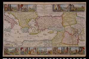
Map: Holy Land-Paul's Wanderings
1990.13.0018
Detailed Images
Basic Information
| Artifact Identification | Map: Holy Land-Paul's Wanderings (1990.13.0018) |
|---|---|
| Classification/ Nomenclature |
|
| Artist/Maker | van der Putte, Isaac |
| Geographic Location | |
| Period | N/A |
| Date | 1750 CE |
| Culture | European |
| Location | Not on Exhibit |
Physical Analysis
| Dimension 1 (N/A) | 32.1 cm |
|---|---|
| Dimension 2 (N/A) | 48.5 cm |
| Dimension 3 (N/A) | N/A |
| Weight | 15 g |
| Measuring Remarks | N/A |
| Materials | paper--rag, pigment--ink, paint |
| Manufacturing Processes | Printed |
Research Remarks
| Description | N/A |
|---|---|
| Published Description | Under Review |
| Bibliography | Under Review |
Artifact History
| Credit Line/Dedication | The Seymour and Muriel Yale Collection of Coins of the Ottoman Empire and Other Middle East States |
|---|---|
| Reproduction | No |
Contact
All information about our collection is constantly reviewed and updated. Please contact Dery Martínez-Bonilla, Registrar, if there is any information you are looking for that isn't currently online.