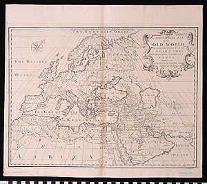
Map: A Geographical Map of the Old World According to the Division of it Among Noah's Sons after the Dispersion of Them Which Happened at Babel
1991.18.0025
Detailed Images
Basic Information
| Artifact Identification | Map: A Geographical Map of the Old World According to the Division of it Among Noah's Sons after the Dispersion of Them Which Happened at Babel (1991.18.0025) |
|---|---|
| Classification/ Nomenclature |
|
| Artist/Maker | Calmet, Augustin Antoine A Historical, Geographical, Critical, Chronological Dictionary of the Holy Bible, Vol. II |
| Geographic Location | |
| Period | N/A |
| Date | 1750 CE |
| Culture | British, English |
| Location | Not on Exhibit |
Physical Analysis
| Dimension 1 (Width) | 46.0 cm |
|---|---|
| Dimension 2 (Height) | 39.8 cm |
| Dimension 3 (Depth) | <0.1 cm |
| Weight | 20 g |
| Measuring Remarks | N/A |
| Materials | paper |
| Manufacturing Processes | Printed |
Research Remarks
| Description | N/A |
|---|---|
| Published Description | N/A |
| Bibliography | Laor, Eran. Maps of the Holy Land: Cartobibliography of Printed Maps, 1475-1900. New York: A. R. Liss, 1986. Catalog #168. |
Artifact History
| Credit Line/Dedication | The Seymour and Muriel Yale Collection of Coins of the Ottoman Empire and Other Middle East States |
|---|---|
| Reproduction | No |
Contact
All information about our collection is constantly reviewed and updated. Please contact Dery Martínez-Bonilla, Registrar, if there is any information you are looking for that isn't currently online.