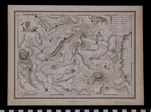
Map: Tribe of Zebulun
1995.25.0070
Detailed Images
Basic Information
| Artifact Identification | Map: Tribe of Zebulun (1995.25.0070) |
|---|---|
| Classification/ Nomenclature |
|
| Artist/Maker | Mathews & Leigh The Scripture Atlas or a Series of Maps to Illustrate the Old and New Testament London, Printed for Mathews & Leigh by L. Harrison and J.C. Leigh, 1812 |
| Geographic Location | |
| Period | George III, 1812 |
| Date | 1800 to 1825 CE |
| Culture | British, English |
| Location | Not on Exhibit |
Physical Analysis
| Dimension 1 (Width) | 28.8 cm |
|---|---|
| Dimension 2 (Height) | 21.3 cm |
| Dimension 3 (Depth) | <0.1 cm |
| Weight | 10 g |
| Measuring Remarks | N/A |
| Materials | paper, pigment--ink |
| Manufacturing Processes | Printed |
Research Remarks
| Description | N/A |
|---|---|
| Published Description | Under Review |
| Bibliography | Laor, Eran. Maps of the Holy Land: Cartobibliography of Printed Maps, 1475-1900. New York: A. R. Liss, 1986. Catalog #472. |
Artifact History
| Credit Line/Dedication | In memory of Muriel Yale. |
|---|---|
| Reproduction | No |
Contact
All information about our collection is constantly reviewed and updated. Please contact Dery Martínez-Bonilla, Registrar, if there is any information you are looking for that isn't currently online.