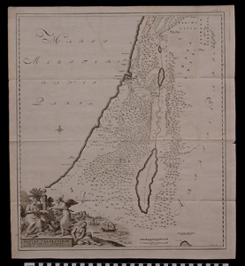
Map: Facies Palestinae Ex Monumentis Veritibus Descripta...
1995.25.0096
Detailed Images
Basic Information
| Artifact Identification | Map: Facies Palestinae Ex Monumentis Veritibus Descripta... (1995.25.0096) |
|---|---|
| Classification/ Nomenclature |
|
| Artist/Maker | Reland, Adrian. Utrecht, Willem Broedelet, 1714. |
| Geographic Location | |
| Period | N/A |
| Date | 1714 CE |
| Culture | Dutch |
| Location | Not on Exhibit |
Physical Analysis
| Dimension 1 (Height) | 60.0 cm |
|---|---|
| Dimension 2 (Width) | 54.0 cm |
| Dimension 3 (Depth) | <0.1 cm |
| Weight | N/A |
| Measuring Remarks | Under Review |
| Materials | paper, pigment--ink |
| Manufacturing Processes | Printed |
Research Remarks
| Description | N/A |
|---|---|
| Published Description | Under Review |
| Bibliography | Laor, Eran. Maps of the Holy Land: Cartobibliography of Printed Maps, 1475-1900. New York: A. R. Liss, 1986. Catalog #643. |
Artifact History
| Credit Line/Dedication | In memory of Muriel Yale. |
|---|---|
| Reproduction | No |
Contact
All information about our collection is constantly reviewed and updated. Please contact Dery Martínez-Bonilla, Registrar, if there is any information you are looking for that isn't currently online.