Search Results - Advanced Search
Displaying Records 1 through 25 of 36 records found
from Great [and] Britain, [and] Greater [and] London
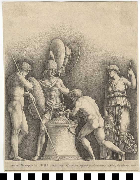
Etching: Roman Sacrifice1941.03.0005 (1941.03.0005)
23.6 x 18.7 cm (5 g)
Location: Europe, West: United Kingdom, England: Great Britain, Greater London: London
Period: Baroque; 17th Century,
Classification/Nomenclature: Communication Artifacts : Art
Period: Baroque; 17th Century,
Classification/Nomenclature: Communication Artifacts : Art
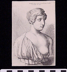
Print of Engraving: Faustina1941.03.0047 (1941.03.0047)
12 x 8 x .1 cm (<1 g)
Location: Europe, West: United Kingdom, England: Great Britain, Greater London: London
Period: Renaissance; 1645 CE
Classification/Nomenclature: Communication Artifacts : Documentary Artifacts : Graphic Documents
Period: Renaissance; 1645 CE
Classification/Nomenclature: Communication Artifacts : Documentary Artifacts : Graphic Documents
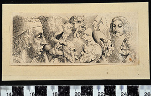
Engraving: Twelve Heads1963.01.0063 (1963.01.0063)
11.3 x 4.6 x .1 cm (0 g)
Location: Europe, West: United Kingdom, England: Great Britain, Greater London: London
Period: renaissance; 1645 CE
Classification/Nomenclature: Communication Artifacts : Documentary Artifacts : Graphic Documents
Period: renaissance; 1645 CE
Classification/Nomenclature: Communication Artifacts : Documentary Artifacts : Graphic Documents
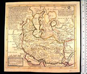
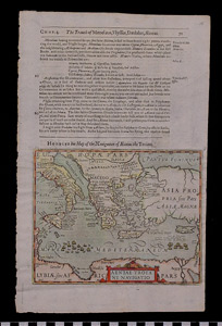
Map: Persia, the Caspian Sea, and Part of Independent Tartary1988.07.0007 (1988.07.0007)
27.9 x 26.3 x .1 cm (9 g)
Location: Europe, West: United Kingdom, England: Great Britain, Greater London: London
Period: Georgian; 1740 CE
Classification/Nomenclature: Communication Artifacts : Documentary Artifacts : Graphic Documents
Period: Georgian; 1740 CE
Classification/Nomenclature: Communication Artifacts : Documentary Artifacts : Graphic Documents
Map: Navigation of Aeneas the Trojan1988.07.0015 (1988.07.0015)
33.6 x 21 x .1 cm (32 g)
Location: Europe, West: United Kingdom, England: Great Britain, Greater London: London
Period: Reformation; 1625 CE
Classification/Nomenclature: Communication Artifacts : Documentary Artifacts : Graphic Documents
Period: Reformation; 1625 CE
Classification/Nomenclature: Communication Artifacts : Documentary Artifacts : Graphic Documents
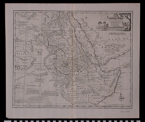
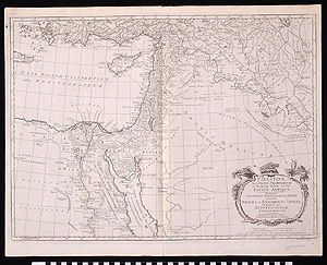
Map: A New and Accurate Map of Nubia and Abissinia1988.07.0040 (1988.07.0040)
48 x 41.3 cm (14 g)
Location: Europe, West: United Kingdom, England: Great Britain, Greater London: London
Period: Georgian; 1747
Classification/Nomenclature: Communication Artifacts : Documentary Artifacts : Graphic Documents
Period: Georgian; 1747
Classification/Nomenclature: Communication Artifacts : Documentary Artifacts : Graphic Documents
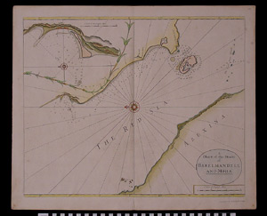
Map: A Chart of the Straits of Babelmandell and Moha1988.07.0049 (1988.07.0049)
60.6 x 50.1 x .1 cm (56 g)
Location: Europe, West: United Kingdom, England: Great Britain, Greater London: London
Period: Georgian; 1748
Classification/Nomenclature: Communication Artifacts : Documentary Artifacts : Graphic Documents
Period: Georgian; 1748
Classification/Nomenclature: Communication Artifacts : Documentary Artifacts : Graphic Documents
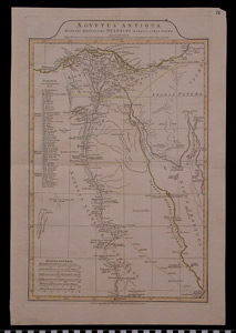
Map: Aegyptus Antiqua1988.07.0050 (1988.07.0050)
54.8 x 37.1 x .1 cm (28 g)
Location: Europe, West: United Kingdom, England: Great Britain, Greater London: London
Period: 1821
Classification/Nomenclature: Communication Artifacts : Documentary Artifacts : Graphic Documents
Period: 1821
Classification/Nomenclature: Communication Artifacts : Documentary Artifacts : Graphic Documents
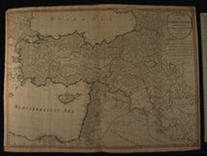
Map: A New Map of Turkey in Asia1988.07.0052 (1988.07.0052)
72.9 x 54.1 x .1 cm (67 g)
Location: Europe, West: United Kingdom, England: Great Britain, Greater London: London
Period: Georgian; 1794
Classification/Nomenclature: Communication Artifacts : Documentary Artifacts : Graphic Documents
Period: Georgian; 1794
Classification/Nomenclature: Communication Artifacts : Documentary Artifacts : Graphic Documents
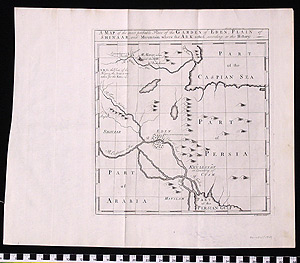
Map: Most Probable Place of the Garden of Eden, Plain of Shinaar, and Mountain Where the Ark Rested, According to the History1989.11.0002 (1989.11.0002)
43.5 x 35.7 x .1 cm (14 g)
Location: Europe, West: United Kingdom, England: Great Britain, Greater London: London
Period: 1747 CE
Classification/Nomenclature: Communication Artifacts : Documentary Artifacts : Graphic Documents
Period: 1747 CE
Classification/Nomenclature: Communication Artifacts : Documentary Artifacts : Graphic Documents
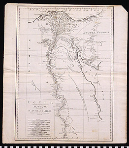
Map: Egypt, Called in the Language of the Country Missir1989.11.0003 (1989.11.0003)
48 x 42.5 x .1 cm (16 g)
Location: Europe, West: United Kingdom, England: Great Britain, Greater London: London
Period: 1788 CE
Classification/Nomenclature: Communication Artifacts : Documentary Artifacts : Graphic Documents
Period: 1788 CE
Classification/Nomenclature: Communication Artifacts : Documentary Artifacts : Graphic Documents
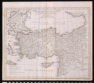
Map: Asiae quae vulgo Minor dicitur et Syria Tabula Geographica1989.11.0004 (1989.11.0004)
49 x 42.7 x .1 cm (24 g)
Location: Europe, West: United Kingdom, England: Great Britain, Greater London: London
Period: 1788 CE`
Classification/Nomenclature: Communication Artifacts : Documentary Artifacts : Graphic Documents
Period: 1788 CE`
Classification/Nomenclature: Communication Artifacts : Documentary Artifacts : Graphic Documents
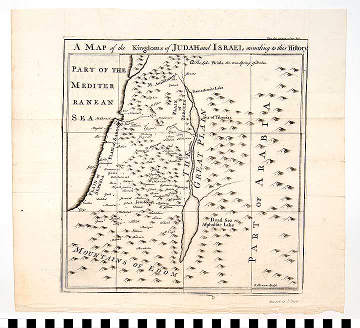
Map: Kingdoms of Judah and Israel1989.11.0006 (1989.11.0006)
35.9 x 32.8 cm (9 g)
Location: Europe, West: United Kingdom, England: Great Britain, Greater London: London
Period: 1747 CE
Classification/Nomenclature: Communication Artifacts : Documentary Artifacts : Graphic Documents
Period: 1747 CE
Classification/Nomenclature: Communication Artifacts : Documentary Artifacts : Graphic Documents
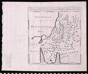
Map: The Divisions & Situations of the Tribes of the Canaanites, Moabites, Ammonites, Midianites, Edomites, Amalekites, & c before & at ye time of ye Exodus of ye Children of Israel1989.11.0007 (1989.11.0007)
44 x 35.8 cm (13 g)
Location: Europe, West: United Kingdom, England: Great Britain, Greater London: London
Period: 1747 CE
Classification/Nomenclature: Communication Artifacts : Documentary Artifacts : Graphic Documents
Period: 1747 CE
Classification/Nomenclature: Communication Artifacts : Documentary Artifacts : Graphic Documents
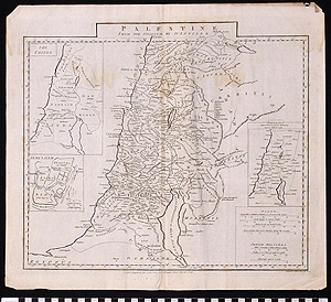
Map: Palestine1989.11.0008 (1989.11.0008)
48.2 x 41.8 x .1 cm (13 g)
Location: Europe, West: United Kingdom, England: Great Britain, Greater London: London
Period: 1788 CE
Classification/Nomenclature: Communication Artifacts : Documentary Artifacts : Graphic Documents
Period: 1788 CE
Classification/Nomenclature: Communication Artifacts : Documentary Artifacts : Graphic Documents
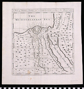
Map: Ancient Egypt and its Circumadjacencies According to this History1989.11.0010 (1989.11.0010)
35.7 x 35 x .1 cm (11 g)
Location: Europe, West: United Kingdom, England: Great Britain, Greater London: London
Period: 1747 CE
Classification/Nomenclature: Communication Artifacts : Documentary Artifacts : Graphic Documents
Period: 1747 CE
Classification/Nomenclature: Communication Artifacts : Documentary Artifacts : Graphic Documents
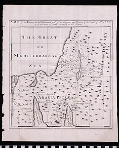
Map: Journey in the Wilderness and of the Conquest and Partition of the Land of Canaan, by the Children of Israel According to that History1989.11.0011 (1989.11.0011)
35.8 x 30.3 x .1 cm (9 g)
Location: Europe, West: United Kingdom, England: Great Britain, Greater London: London
Period: 1747 CE
Classification/Nomenclature: Communication Artifacts : Documentary Artifacts : Graphic Documents
Period: 1747 CE
Classification/Nomenclature: Communication Artifacts : Documentary Artifacts : Graphic Documents
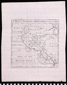
Map: Assyria and Babylonia1989.11.0012 (1989.11.0012)
44.5 x 36 x .1 cm (11 g)
Location: Europe, West: United Kingdom, England: Great Britain, Greater London: London
Period: 1747 CE
Classification/Nomenclature: Communication Artifacts : Documentary Artifacts : Graphic Documents
Period: 1747 CE
Classification/Nomenclature: Communication Artifacts : Documentary Artifacts : Graphic Documents
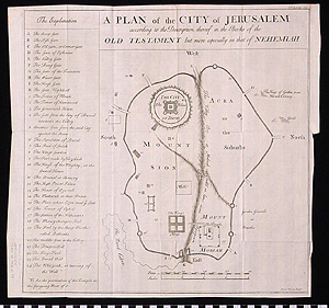
Map: A PLAN of the CITY of JERUSALEM according to the Description thereof in the Books of the OLD TESTAMENT but more expecially in that of NEHEMIAH1989.11.0013 (1989.11.0013)
44.5 x 41.8 cm (11 g)
Location: Europe, West: United Kingdom, England: Great Britain, Greater London: London
Period: 1747
Classification/Nomenclature: Communication Artifacts : Documentary Artifacts : Graphic Documents
Period: 1747
Classification/Nomenclature: Communication Artifacts : Documentary Artifacts : Graphic Documents
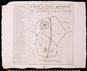
Map: A PLAN of the CITYof JERUSALEM according to the Description thereof in the Books of the OLD TESTAMENT but more expecially in that of NEHEMIAH.1989.11.0014 (1989.11.0014)
57 x 45.4 x .1 cm (25 g)
Location: Europe, West: United Kingdom, England: Great Britain, Greater London: London
Period: 1762
Classification/Nomenclature: Communication Artifacts : Documentary Artifacts : Graphic Documents
Period: 1762
Classification/Nomenclature: Communication Artifacts : Documentary Artifacts : Graphic Documents
Map: Palestinae Seu Terrae Promissionis1989.11.0019 (1989.11.0019)
59.5 x 46.8 x .1 cm (43 g)
Location: Europe, West: United Kingdom, England: Great Britain, Greater London: London
Period: 1790 CE
Classification/Nomenclature: Communication Artifacts : Documentary Artifacts : Graphic Documents
Period: 1790 CE
Classification/Nomenclature: Communication Artifacts : Documentary Artifacts : Graphic Documents
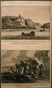
Engraving: St. Salvador; The Manner of Traveling1989.11.0028 (1989.11.0028)
40.8 x 25.4 cm (154 g)
Location: Europe, West: United Kingdom, England: Great Britain, Greater London: London
Period: Early Colonial; 1790 CE
Classification/Nomenclature: Communication Artifacts : Documentary Artifacts : Graphic Documents
Period: Early Colonial; 1790 CE
Classification/Nomenclature: Communication Artifacts : Documentary Artifacts : Graphic Documents
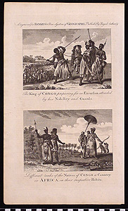
Engraving: The King of the Congo; Different Ranks of the Natives1989.11.0029 (1989.11.0029)
38.4 x 22.9 x .1 cm (8 g)
Location: Europe, West: United Kingdom, England: Great Britain, Greater London: London
Period: 1790
Classification/Nomenclature: Communication Artifacts : Documentary Artifacts : Graphic Documents
Period: 1790
Classification/Nomenclature: Communication Artifacts : Documentary Artifacts : Graphic Documents
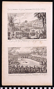
Engraving: Procession of the People of Widah; Ceremonies used at the Coronation of the King1989.11.0030 (1989.11.0030)
38.3 x 23 x .1 cm (10 g)
Location: Europe, West: United Kingdom, England: Great Britain, Greater London: London
Period: 1790 CE
Classification/Nomenclature: Communication Artifacts : Documentary Artifacts : Graphic Documents
Period: 1790 CE
Classification/Nomenclature: Communication Artifacts : Documentary Artifacts : Graphic Documents
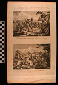
Engraving: Hottentot Enterntainment; Marriage Ceremony of the Hottentots1989.11.0031 (1989.11.0031)
37.8 x 23 x .1 cm (10 g)
Location: Europe, West: United Kingdom, England: Great Britain, Greater London: London
Period: 1790 CE
Classification/Nomenclature: Communication Artifacts : Documentary Artifacts : Graphic Documents
Period: 1790 CE
Classification/Nomenclature: Communication Artifacts : Documentary Artifacts : Graphic Documents
Search Examples
Explore More
Access the public portions of the catalog records for the approximately 50,000 cultural and ethnographic objects in the Museum's Artifact Collection.